
The Conservation Area Planning Information Guide
A conservation area is a place of “special architectural or historical interest,” which the Planning Authority must preserve and enhance.
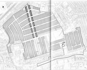
Westminster City Council – the Planning Authority for Queen’s Park – designated the Queen’s Park Estate as a Conservation Area in 1978. In 1991, WCC extended the Conservation Area to include the Harrow Road Library and some buildings alongside the Grand Union Canal.
Today the Queen’s Park Conservation Area includes 1,500 residential properties, 53 Grade II listed properties on Fifth Avenue between Ilbert Street and Kilburn Lane, the Queen’s Park Meeting Hall (578-580 Harrow Road) and the Droop Street School.
The Queen’s Park Conservation Area Planning Information Guide supports owner-occupiers, landlords (both private and social), tenants, builders and architects to ensure development or alteration do not affect the unique character of the Conservation Area. Residents are encouraged to refer to the Queen’s Park Conservation Area Planning Information Guide before making any alterations or submitting planning applications. Failure to do so may result in enforcement proceedings against you, requiring you to undo the development or alteration at your own cost.
Download the Queen’s Park Conservation Area Planning Information Guide.